The draft available for review below is the first module of the Los Alamos County Development Code Update focusing on use regulations. It contains revisions to the zoning districts, the permissive use table (AKA Use Index Table), use-specific regulations and use related definitions. Two subsequent modules will be released later this year focusing on development standards and procedures, respectively.
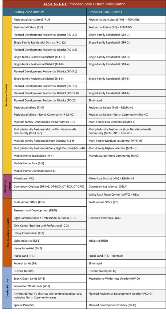
The following table shows the Los Alamos County’s current zoning districts in relation to proposed zoning districts. Where districts were reclassified, the following summary reflects the zone conversion rules for base zones from the existing Development Code:
- Where two or more existing zones that were very similar in terms of permissive land uses and densities, districts were consolidated into one proposed district that allows uses for the highest base zone.
- Where zones existed that are no longer used or are currently not mapped anywhere in the County were eliminated.
- Planned residential districts (PD), which are no longer accepted by the County as of August 28, 2007, were converted to the closest residential base zone in regard to permissive land uses and densities. Where planned developments contained undeveloped lots, the reclassification followed the above-mentioned conversion, but approved site plan entitlements were carried over through the new Planned Residential Development Overlay District.
The map below shows the proposed zoning and the existing zoning. The proposed zoning conversions may be found by clicking on a specific property on the map.
To review public comments received on Module 1 thus far, click HERE